16.10.2026
Attention
Snowmelt and heavy rainfall expected in western part of Iceland
- Snowmelt expected in western and northern Iceland.
- Snowmelt combined with heavy rainfall expected in western Iceland.
- Yellow landslide warnings issued for Strandir, the Northern Westfjords and the Southern Westfjords.
Two low-pressure systems are approaching Iceland from the southwest. The first will track northward along Greenland’s east coast, with its effects expected to reach Iceland during the afternoon of Saturday, 17 October. The second system will move along Iceland’s west coast on the morning of Sunday, 18 October. Both systems are expected to bring warmer air and precipitation, promoting snowmelt.
The highest accumulated precipitation is forecast for western and southern Iceland. Heavy precipitation is expected in the Westfjords, on Snæfellsnes, and along the south coast near glacier areas. In some locations, particularly near glaciers, total precipitation amounts may become high during the period.
On Wednesday, a deep low-pressure system approached eastern Iceland, bringing heavy rain initially, followed by snowfall at low elevations in western and northern Iceland. Snow has melted at low elevations and up to mid-slopes in many areas, but snow remains in the mountains, with depth varying between regions. Snowmelt is expected in western and northern Iceland through Monday.
In the Westfjords, Strandir and on the Snæfellsnes Peninsula, rain is expected to fall onto the existing mountain snowpack. Under such conditions, the ground may become saturated, potentially triggering landslides or rockfalls. Consequently, an increased risk of slope failures is expected.
Landslides and rockfalls may reach roads and other transport infrastructure with little or no warning, causing disruptions to traffic. At present, no threat to populated areas is expected
A landslide warning has been issued due to snowmelt and rainfall for the Northern Westfjords, the Southern Westfjords and Strandir area.
The landslide monitoring watch at the Icelandic Met Office will monitor the situation during the weekend.
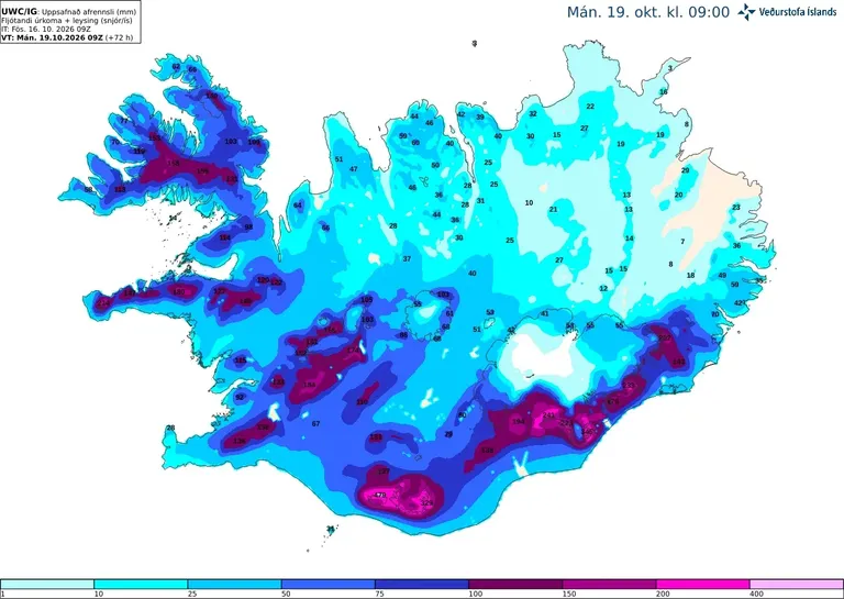
The images show high runoff around the glaciers, in the highlands in the south west and around Northern and Southern part of Westfjords and Strandir area
The public is encouraged to report landslides and rockfalls to the Landslide Monitoring Service. Reports can be submitted by email to skriduvakt@vedur.is or through the online avalanche and landslide reporting form. Please provide the exact location and the time when the landslide or rockfall occurred whenever possible. If the timing is unknown, it is sufficient to indicate when it was first observed. Photographs are highly valuable and should be included if available. Reports are reviewed by the Landslide Monitoring Service and, where possible, verified before being entered into the Icelandic Meteorological Office's snow avalanche and landslide database.