26.10.2026
Precipitation and snowmelt on Tuesday, 27 October
- Precipitation and snowmelt are expected on Tuesday.
- Increased runoff from slopes and higher water levels in rivers and streams.
- Rockfalls and shallow landslides cannot be ruled out. Exercise caution when travelling beneath steep slopes.
The weather forecast predicts a precipitation front moving across Iceland from the early hours of Tuesday, 27 October. Precipitation will begin in the southeast before spreading across most of the country. The heaviest precipitation is expected near and south of Vatnajökull, in the Eastfjords, on the Flateyjarskagi peninsula and in Strandir. The front will move relatively quickly across the country, and conditions are expected to clear on Wednesday.
According to the forecast, the highest accumulated precipitation is expected in Strandir, particularly over glaciers and in mountainous areas, in the northernmost part of the Tröllaskagi peninsula, on the Flateyjarskagi peninsula, in Vesturkinn (the mountains east of Vopnafjörður), in the northern Eastfjords and in Öræfi.
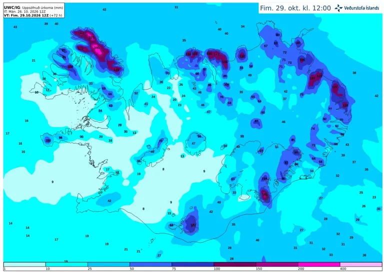
Accumulated precipitation over the next 72 hours, according to the IG weather model.
Rain is expected at lower elevations, with sleet or snow in the mountains. Where snow is already present, such as in North Iceland, snowmelt combined with precipitation will increase the amount of water draining from mountain slopes. In addition, the weather has been wet in recent days.
Increased water flow in rivers and streams, as well as increased runoff from slopes, is therefore expected. Slope movements, such as rockfalls and shallow landslides, cannot be ruled out. At present, no threat from landslides is considered likely in inhabited areas. However, caution is advised when travelling, particularly beneath steep slopes.
The Icelandic Met Office’s Landslide Watch urges people who need to travel to exercise caution on roads, especially beneath steep slopes and in known rockfall areas, and to monitor information on the Icelandic Road and Coastal Administration’s website. The public is encouraged to report landslides and rockfalls to the Landslide Watch. Reports can be sent by email to skriduvakt@vedur.is or submitted using the online form for reporting landslides and other slope hazards. Please include the exact location and the time when the landslide or rockfall occurred. If the time is unknown, it is sufficient to state when it was first noticed. Photographs are welcome whenever possible. The Landslide Watch reviews reports and attempts to verify them before they are entered into the Icelandic Met Office’s landslide database.